Skip to content

Climate.Park.Change. Research Project Featured on Archinect

The following is an excerpt from Archinect’s article published on June 14, 2021

With Climate.Park.Change., Sasaki has developed an interactive tool which allows parkland operators and users to understand the environmental dangers facing America’s parks, and develop strategies in response. Using an interactive map, users can navigate to their preferred region (currently focused on selected western states of the USA) to understand the various climate issues for parklands in that region. Users are then offered a portfolio of strategies tailored for specific geographies, as well as three case studies demonstrating how the toolkit can be used to identify and tackle these issues.

To develop the tool, Sasaki partnered with the National Recreation and Park Association (NRPA). Through engagements with the NRPA’s Innovation Lab in Miami, Florida, the team noted that the national discourse on infrastructure and parkland resiliency against climate change was focused heavily on coastal systems. “Only ten percent of our land is on the coast,” says Anna Cawrse, landscape architect at Sasaki and one of the tool’s creators. “There was a need to translate this great work on coastal strategies to inland areas. Together with the NRPA we set out on creating a toolkit starting at the Intermountain West, an area of the country that was missing from the discourse.” Working with Sasaki’s internal mix of ecologists, civil engineers, urban designers, and landscape architects, the team embarked on developing an accessible toolkit to broaden both the conversation and access to knowledge for protecting America’s parks from climate change.

“Creating an accessible tool was fundamental for us,” says Cawrse. “Often when we talk about climate change, the discussion can become overly academic and intimidating for someone who is seeking answers and strategies. Our goal was to make this knowledge accessible to as many people as possible. Park agencies have the choice of using the tool to engage with these strategies at a high level, but also to explore the issues and measures in greater detail, and take a deep dive into the many layers of information associated with them.”

As well as developing a tool that would be insightful to both experts and the public, the team also faced the challenge of designing strategies that could be specific enough to effect meaningful change at a given park, but universal enough to be applied without extensive local adaption. As well as developing a tool that would be insightful to both experts and the public, the team also faced the challenge of designing strategies that could be specific enough to effect meaningful change at a given park, but universal enough to be applied without extensive local adaption. “The strategies needed to appeal to everything from downtown pocket parks to major park systems stretching thousands of acres,” explains Cawrse. “The tool needed to be transferable across locations and scales.”

Part of the team’s solution was to take their strategies into the real world by working with three different parks in Salt Lake City, Denver, and Evanston, Wyoming. By working with these three parks, varying widely in location and context, the team generated over 50 strategies deriving from their understanding of each specific park. “Once we developed this range of strategies from each location, we could cross-check them with other parks to make sure they were more broadly applicable,” explains Cawrse. “This not only confirmed that these strategies were realistic but also allowed us to develop additional strategies which were both flexible and effective.”

“The future is about coming together, whether in a thousand-acre mountain park or a small backyard, and recognizing that everybody can help our environment adapt and mitigate against climate change.”

Anna Cawrse

As with all the tools explored in this article, Climate.Park.Change will continue to evolve in response to new data and ideas. “We want this to be a living document,” says Cawrse, explaining how the team will continue to add new strategies that emerge from various park agencies, as well as expanding the tool’s coverage to other states beyond its Intermountain West base. The team also sees an opportunity for Climate.Park.Change to host links and resources for other tools and datasets. “We have already had people reach out to us about other resources,” Cawrse explains. “Often these disparate resources are not linked by any central source. Our vision is for users to visit our tool, and use these links to continue their deep dive into other climate change strategies.”

In addition to this vision of a connected network of strategies, the team is also determined to continue with an ethos of accessibility. “Our hope is that the toolkit can be so accessible that an ordinary park user could come here and realize there are small steps they can take, even in their back yard, that can make an impact,” says Cawrse. “The future is about coming together, whether in a thousand-acre mountain park or a small backyard, and recognizing that everybody can help our environment adapt and mitigate against climate change.”

Sasaki Strategies on the link between design and software

Climate.Park.Change. is one of a growing list of engaging software and applications to emerge from Sasaki Strategies; a dedicated group within Sasaki comprised of designers, planners, data scientists, and software developers. The group’s output can vary widely, from interactive apps like Climate.Park.Change to community engagement, data visualization, and storytelling. “Our team grew out of our planning practice,” explains Ken Goulding, who leads the Sasaki Strategies team. “We didn’t originally set out to design software, but over time we continually noticed opportunities to use software in creative ways, be it for animation, storytelling, or automation. This creative platform then steadily evolved into developing actual tools. In that sense, we grew organically from the needs of the practice.”

'We didn’t originally set out to design software, but over time we continually noticed opportunities to use software in creative ways, be it for animation, storytelling, or automation. This creative platform then steadily evolved into developing actual tools. In that sense, we grew organically from the needs of the practice."

Ken Goulding

While operating as a defined team within Sasaki, the Strategies group maintains a strong link with the firm’s architecture, planning, and landscape teams, harnessing data and interactive tools that help their colleagues, as well as clients, understand and develop a design. “A clear majority of the time, our work is in response to the needs of a project team,” says Goulding. “Our other disciplines will notice a gap in the development of a project that we can help fill using digital tools. Other times, however, our work can involve standing back and surveying the wider industry, adopting a ‘research and development role’ of identifying opportunities that our teams or clients aren’t directly asking for.”

“One of the great benefits to having a dedicated in-house team like Sasaki Strategies is accessibility,” says Goulding’s colleague Chris Hardy. “Project managers and designers can meet us without delay, and develop solutions without the process itself becoming a project barrier. Without this in-house team, even having initial conversations with outside developers can be expensive, and coupled with the time delay, can form a barrier to creating something interesting. But we’ve lowered the threshold to a point where we not only produce great work but have perhaps also procured certain projects specifically because of this in-house team.”

The projects emanating from Sasaki Strategies are closely aligned with some of the most pressing issues facing both architecture and cities. Earlier this year, for example, the team developed a tool to help office managers quantify how much office space they would need for their staff following the COVID-19 pandemic. Meanwhile, projects such as Climate.Park.Change, and Hardy’s upcoming tool for measuring embodied carbon in landscape architecture, demonstrate the need for using digital tools to understand the role of urban planning in either contributing to or mitigating against climate change.

“One of the great benefits to having a dedicated in-house team like Sasaki Strategies is accessibility. Project managers and designers can meet us without delay, and develop solutions without the process itself becoming a project barrier."

Chris Hardy

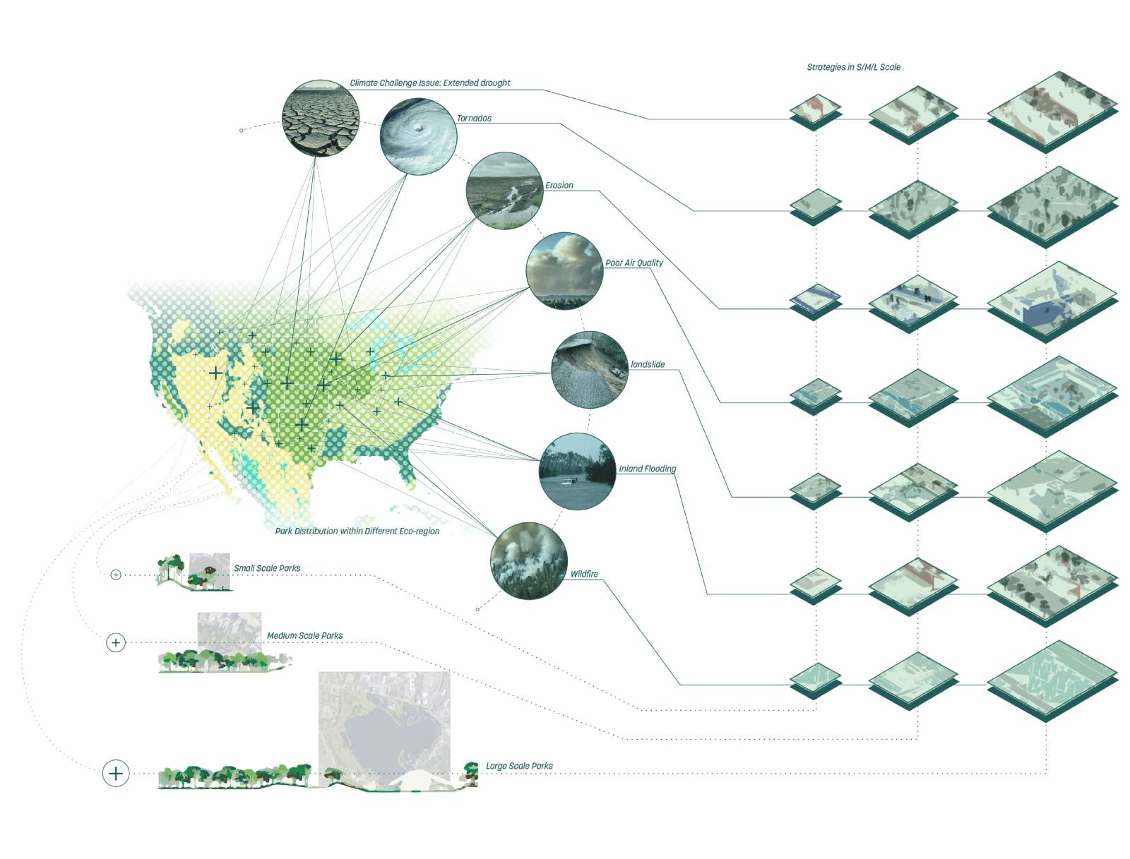
Anna Cawrse, who led the Climate.Park.Change. tool, cites a specific example of Sasaki Strategies integrating with the practice’s other disciplines; a collaboration with Sasaki’s civil engineering and landscape team on dredging works to a six-lake landscape in Baton Rouge, Louisiana. The lakes and parklands currently serve as an important recreational asset for the local community, some of whom voiced nervousness over the project’s redistribution of 600,000 cubic yards of soil for redistribution along the lake edge to create parklands and aid restoration. With some residents worried about the impact of the works on their views of the lake, Sasaki’s team developed a digital model of the landscape, including every single building surrounding the lake, to aid design development.

“Using the model, we can evaluate and communicate in detail the impact of the new soil on surrounding views,” says Cawrse. “Even though no work has been done to the site, the model is allowing us to communicate the challenges and ideas in a way that nobody thought we could do, as opposed to just offering the residents anecdotal assurances. With digital tools, we can definitively prove it, which has been a major benefit to both us, our client, and the residents.” Like Goulding and Hardy, Cawrse sees strength in the Sasaki Strategies team’s ability to reach across disciplines and scales. “In Baton Rouge, we worked with the team on this major engineering, environmental, and recreational project,” Cawrse says. “But we’ve also worked with them on a small quarter-acre plaza, looking at human comfort and the experience of viewing the plaza from various angles. This collaboration can go from ten linear miles of parklands to a quarter-acre site.”

Perhaps one of the most intriguing elements of Sasaki Strategies is the active involvement of people from architectural backgrounds, now engaged in developing digital tools. While the tactile, physical grounding of buildings appears divorced from the virtual world of coding, scripts, and data, the team observes inherent links between the two. “In some ways, it’s the same process,” says Goulding, who also comes from an architectural background. “You’re using empathy, an understanding of user experience, and an ability to understand schematics; steadily allowing the project to evolve in detail. Even concepts of modularity and scalability are directly linked to both realms.”

“An architectural education can be hugely helpful in a career for software and interactive tools,” Goulding adds. “I’ve seen many people in our team start in an architecture background, and successfully transition into understanding and working with software. Often, software has a reputation for being detail-orientated. When you come from a design background, it can instead be easier to think conceptually. But even if you do not fully understand the details, it’s often amazing what you are able to do.”

To explore more information about Climate.Park.Change., visit the following links:

National Recreation and Park Association (NRPA): New Toolkit to Asses Climate Threats and Park-Specific Strategies

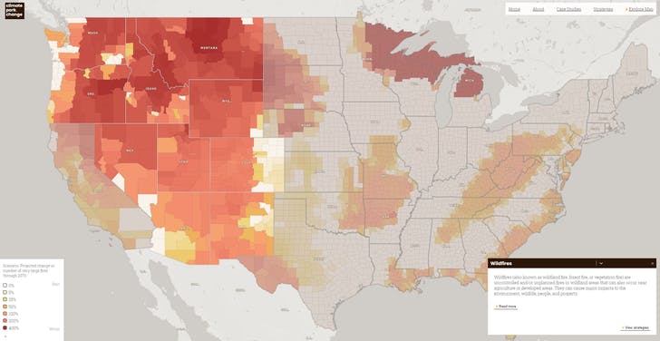
Fast Company Magazine: This map shows the climate impacts on every county in the Western U.S.

World Landscape Architecture: A Comprehensive New Resource for Park and Recreation Agencies Fighting Climate Change

Next City: New Mapping Tool Helps Parks Plan for Climate Change

Sasaki colorful logo Sasaki English