Climate Ready Boston Released
Today marks the release of Climate Ready Boston, a bold initiative that examines the possible impacts of climate change to the city over the next century. You can download the complete report here, or read on for a high-level overview below.
It’s a roadmap for Boston to be better prepared for coastal, riverine, and stormwater flooding and impacts of heat. The report identifies vulnerabilities, analyzes, and quantifies projected annualized losses, and outlines opportunities to mitigate impacts. In addition to protecting against future flooding and other impacts, resiliency planning works towards opportunities to make Boston an increasingly livable city. Climate Ready Boston offers approaches to preparing the city for uncertain future events, improving the city’s vibrancy, and spurring responsible economic development. Boston’s work in this topic area has very real implications for the future of the city, but also sets an example for resilience planning and investment that leads the region and the nation.
Climate Ready Boston builds on years of research and discussion on sea level rise in the city. A series of related studies were conducted by a mixture of civic, non-profit, and for-profit entities, including: the City of Boston, Boston Harbor Now, Sasaki, and the Green Ribbon Commission. This precedent work culminated in the City of Boston successfully applying for a Department of Coastal Zone Management grant to complete a detailed vulnerability assessment.
This initiative is led by the City of Boston in partnership with the Green Ribbon Commission and the Massachusetts Office of Coastal Zone Management to develop resilient solutions which will prepare our city for climate change.
The City of Boston and the Green Ribbon Commission selected Arcadis, an engineering firm, and Sasaki, a Boston-based design and planning firm, to conduct the study. Also involved is the Green Ribbon Commission, HR&A, and the University of Massachusetts Boston School for the Environment.

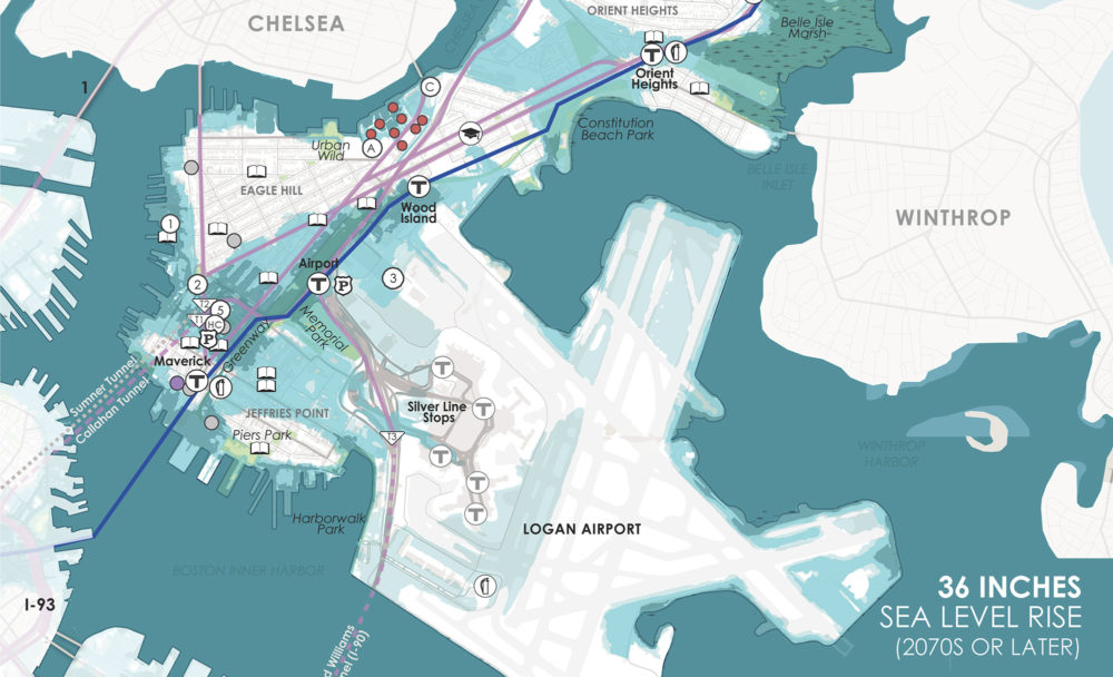
This map details the areas of Boston that would be regularly impacted by sea level rise in the 2070s
Without action, our projections indicate that:
Rising sea levels mean that flooding from major storms will occur much more frequently. A flood that has only a 1% chance of occurring in any given year right now will be roughly equivalent to the regular high tide later this century. Risks associated with heat will continue to climb, causing serious, but preventable, impacts to health. While issues of stormwater flooding and heat will impact populations across the city, coastal flooding will have a concentrated impact on several neighborhoods: East Boston, South Boston, Downtown, and Charlestown in the near-term, and the South End later in the century.
Our research drives home the fact that humans’ response today has a direct and significant impact on how severe sea level rise will be in 100 years. Looking at the short term, we will see higher sea levels, higher “king tides,” and greater storm surges. Too often in the past, flood protection has focused on gray infrastructure such as flood walls. Now, with growing needs and limited funding, we’re looking at solutions that serve “resiliency dividends”—options that respond to these events while simultaneously improving the city. Parks can double as holding space for flood water, for instance, or levees can create coastal protection that incorporate recreational trail systems.
Additionally, the need for public outreach and education on the topic has never been more important. By helping everyone—from residents to large-scale developers—understand how even simple behavioral changes can positively impact our collective fate, we can work towards a brighter, more sustainable future together. A significant reduction in carbon emissions, for example, could mean the difference between 3’ or 8’ of sea level rise—a huge difference—by the 2070s.
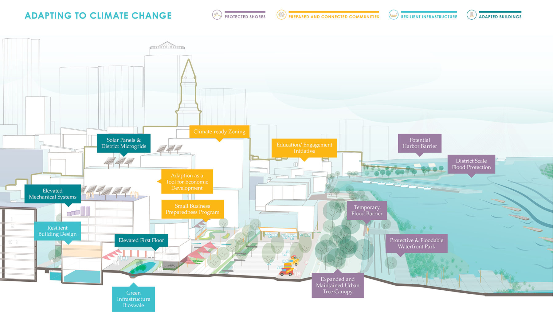
There are many strategies—both large and small—that can help us effectively prepare for climate change
While impacts will continue to grow over the course of the century, we’ll start experiencing real effects in the near-term. By 2030s, seas could be 9” higher than they are today and could expose 8% of the City’s total land area to flooding in a large storm.
Additionally, it was surprising to find that some of the areas most at risk are also growth and development areas for the City of Boston (the Seaport and East Boston). This seems counterintuitive in some ways, but also offers an opportunity to leverage the billions in investment in those areas to build in a sustainable and resilient way.
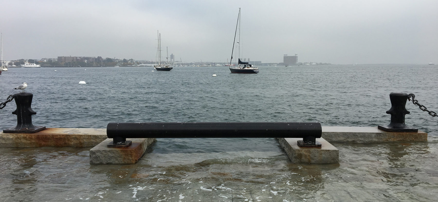
Boston’s harbor is well protected by the Harbor Islands, which buffer the city from waves and storm surge. In Boston’s earlier years, this protection allowed for a sense of security when much of the city’s current area was being filled in during the 1800s. In creating this new land, early residents only built a few feet above high tide. But, today, as seas are rising, much of the filled land is once again at risk of more frequent flooding. As the recent “king tides” have been made very clear, properties and infrastructure at these low elevations will need to address higher flood risks in the coming years.
Waves from a recent “king tide” crest a sea wall in Downtown Boston
Geographically, different parts of the city will be impacted by different hazards. Coastal neighborhoods will be at higher risk of flooding. Inland neighborhoods will be exposed to greater impacts of heat—many areas are already regarded as “heat islands.” All neighborhoods will be exposed to increased stormwater flooding if there are not significant improvements to infrastructure—especially in low-lying areas.
Additionally, some residents are more vulnerable to impacts. Climate Ready Boston looks at seven major categories of socially vulnerable residents—such as the elderly, who might lose access to necessary medical equipment in power outages, or those with lower incomes, who might lack the resources to evacuate the city if public transit fails. Action needs to be prioritized to address areas of Boston where there is significant overlap between these vulnerable populations and projected climate-change impacts.
Climate Ready Boston offers several potential strategies to preparing the city for what lies ahead. One of first follow-up initiatives will be looking at resilience solutions that address near-term flood entry points in Charlestown and East Boston.
The project kicked off in November 2015. The full report was released today, December 8 2016, at a press event and panel discussion hosted by the City of Boston.