Jinan Central Business District Landscape Design
Jinan, China
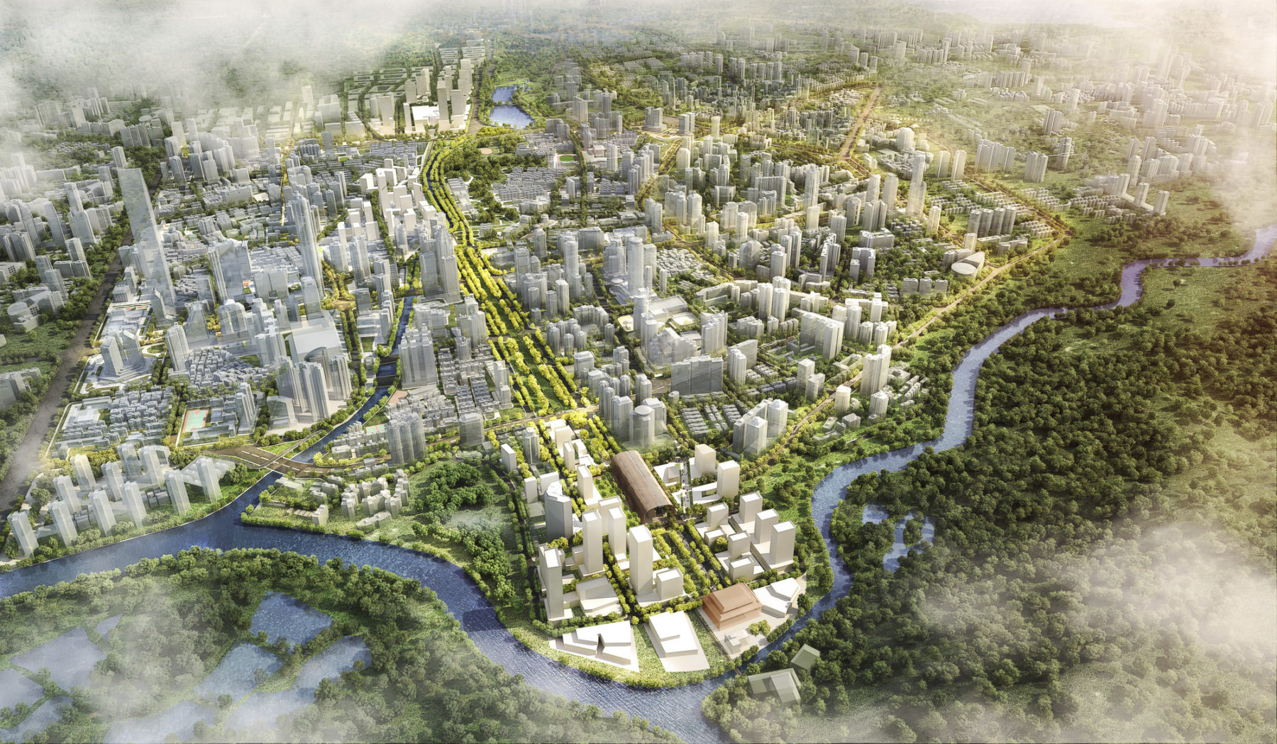
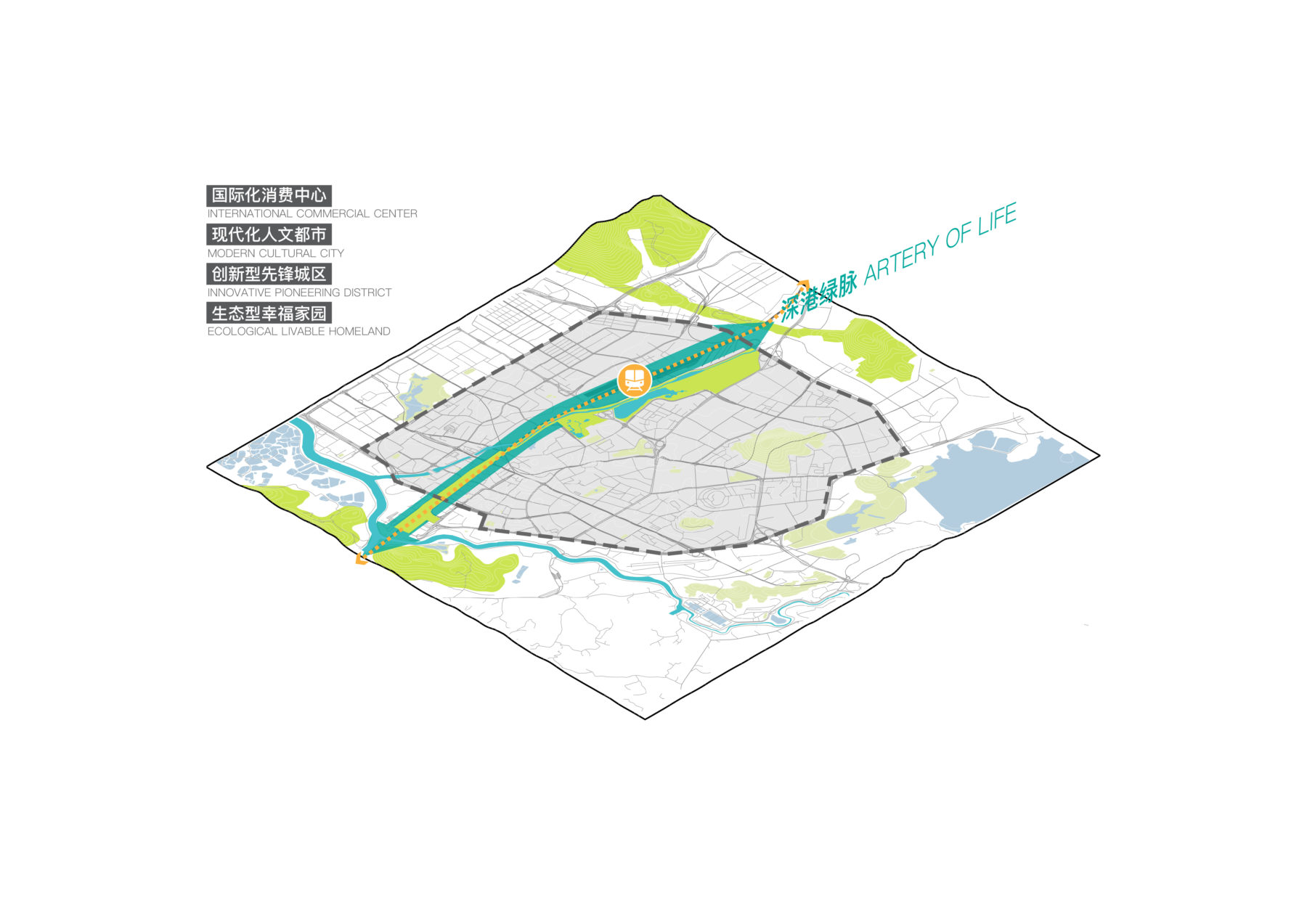
The railway corridor will be transformed into the “Artery of life” to catalyze the urban regeneration and industrial iteration of adjacent areas
After 40 years of development, Shenzhen’s Luohu District, the first gateway connecting Hong Kong and mainland China, is long due for revitalization. Both the district’s urban environment and its traditional industries no longer match Shenzhen’s growing status as a first-tier Chinese city. Luohu, Shenzhen’s first district, needs a large makeover to strengthen its regional competitiveness.
A lack of planning during Shenzhen’s early period of urbanization and rapid population growth have caused many issues in Luohu today. An outdated transit system, incomplete bicycle and pedestrian networks, unappealing public realm, and oversized industrial and transportation uses dominating the physical center of the district have slowed the area’s growth.
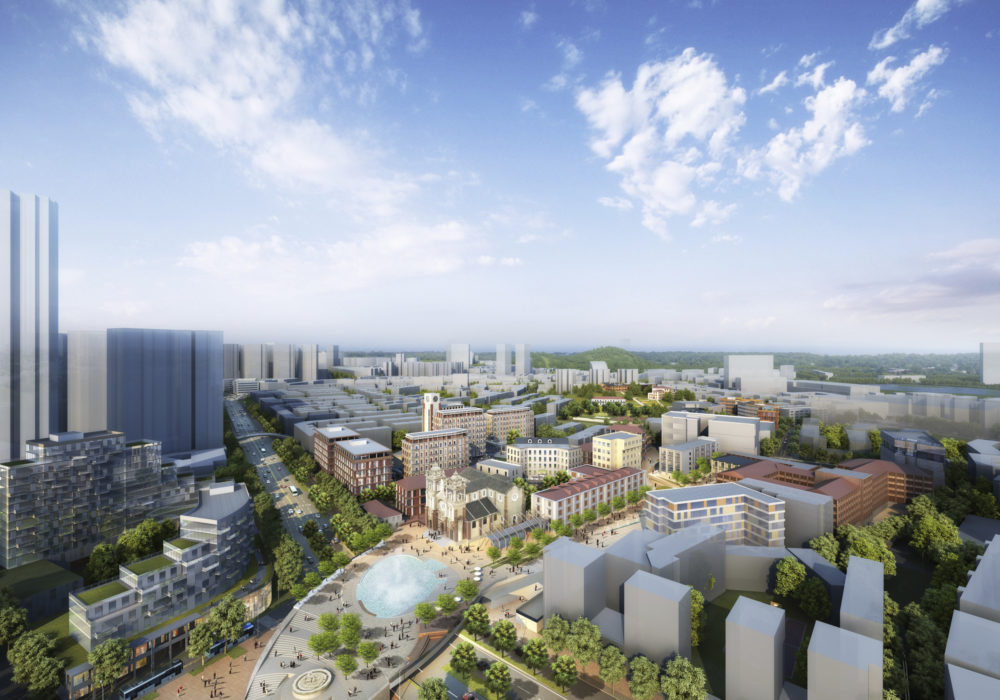
This project aims to systematically improve the public realm and urban structure of Luohu, aligning its urban regeneration efforts with its position as the commercial center of Shenzhen, China’s first special economic zone.
This project aims to systematically improve the image of Luohu while meticulously elevate the spatial quality of its public realms.
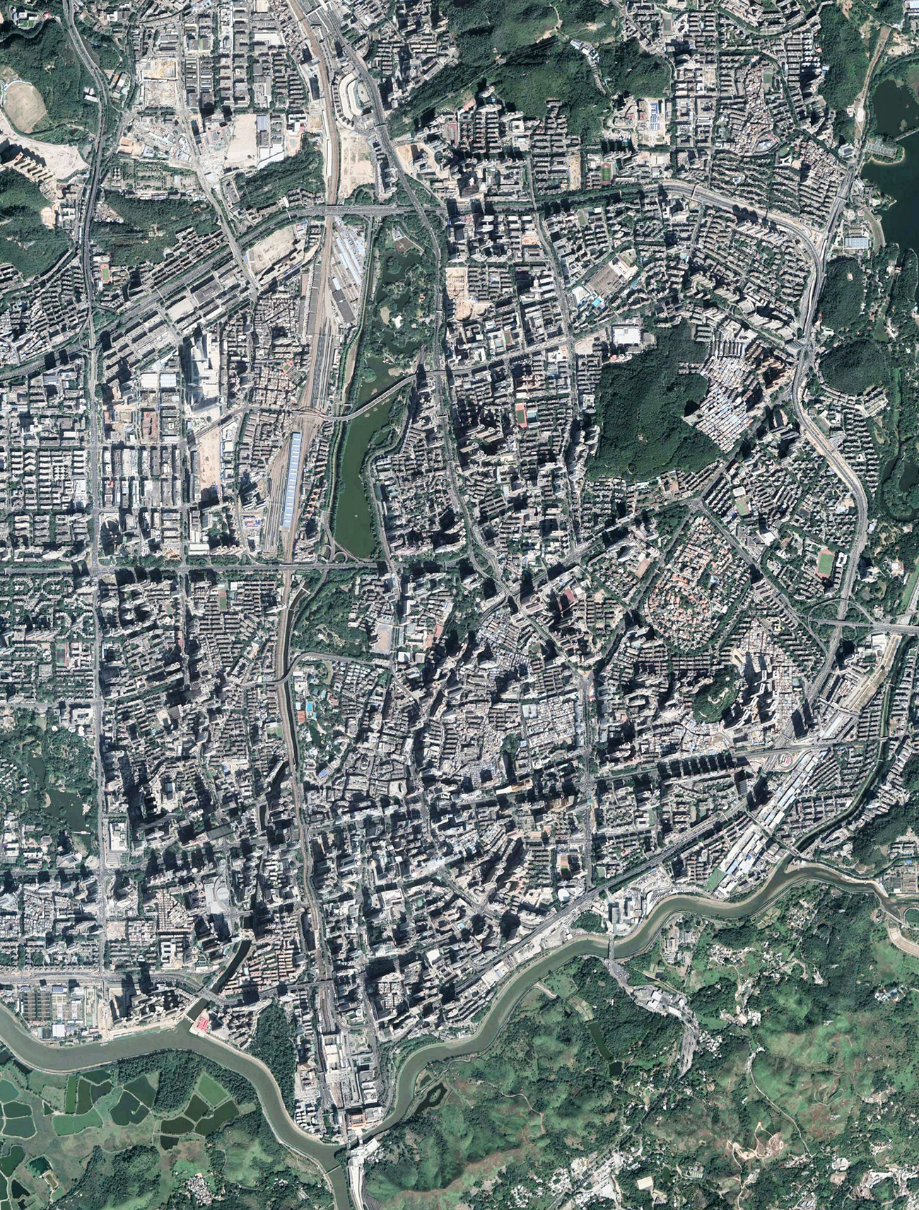
Luohu is facing numerous challenges in its urban environment, including low traffic capacity, an antiquated transit system, poor spatial quality of some streets, and inefficient land use
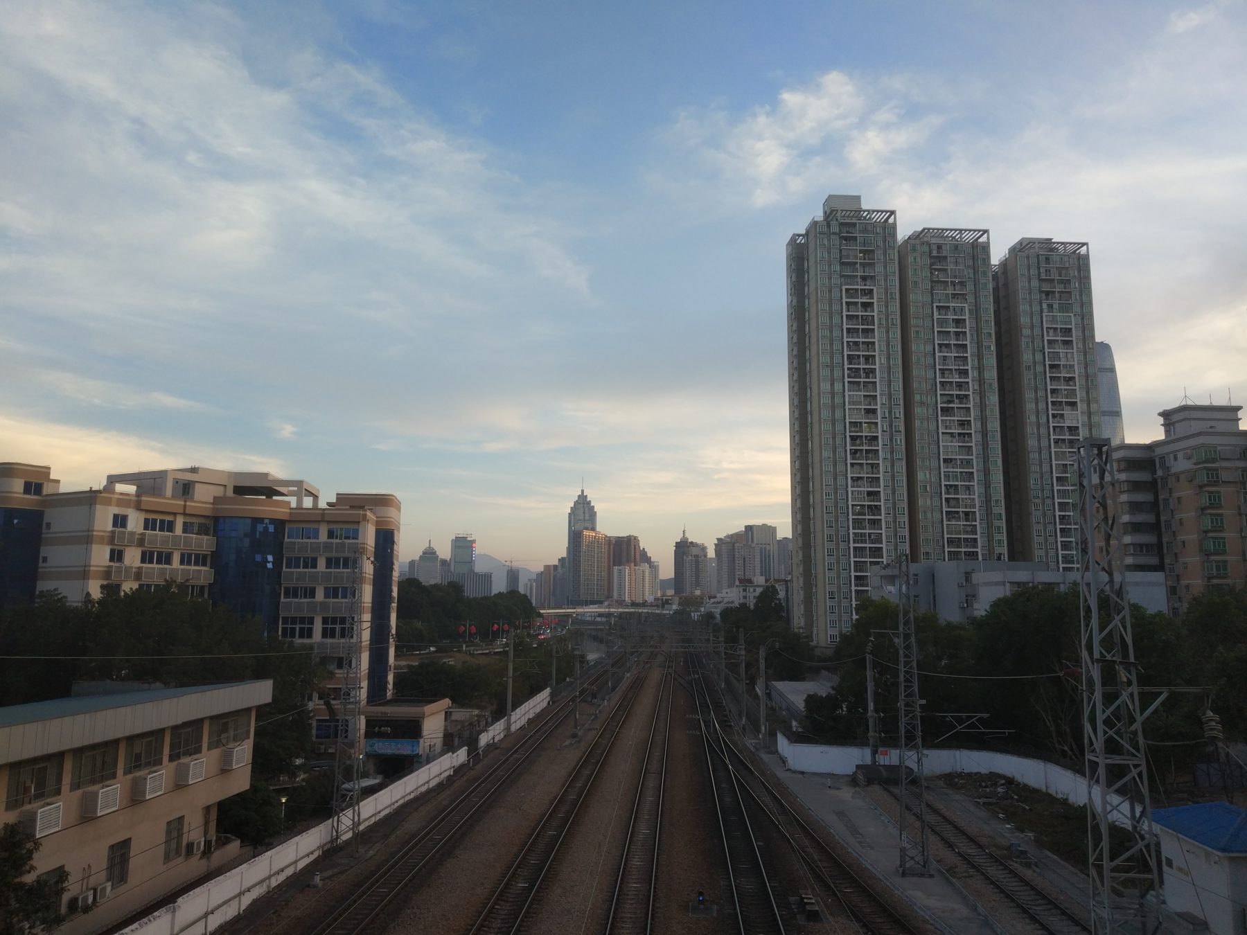
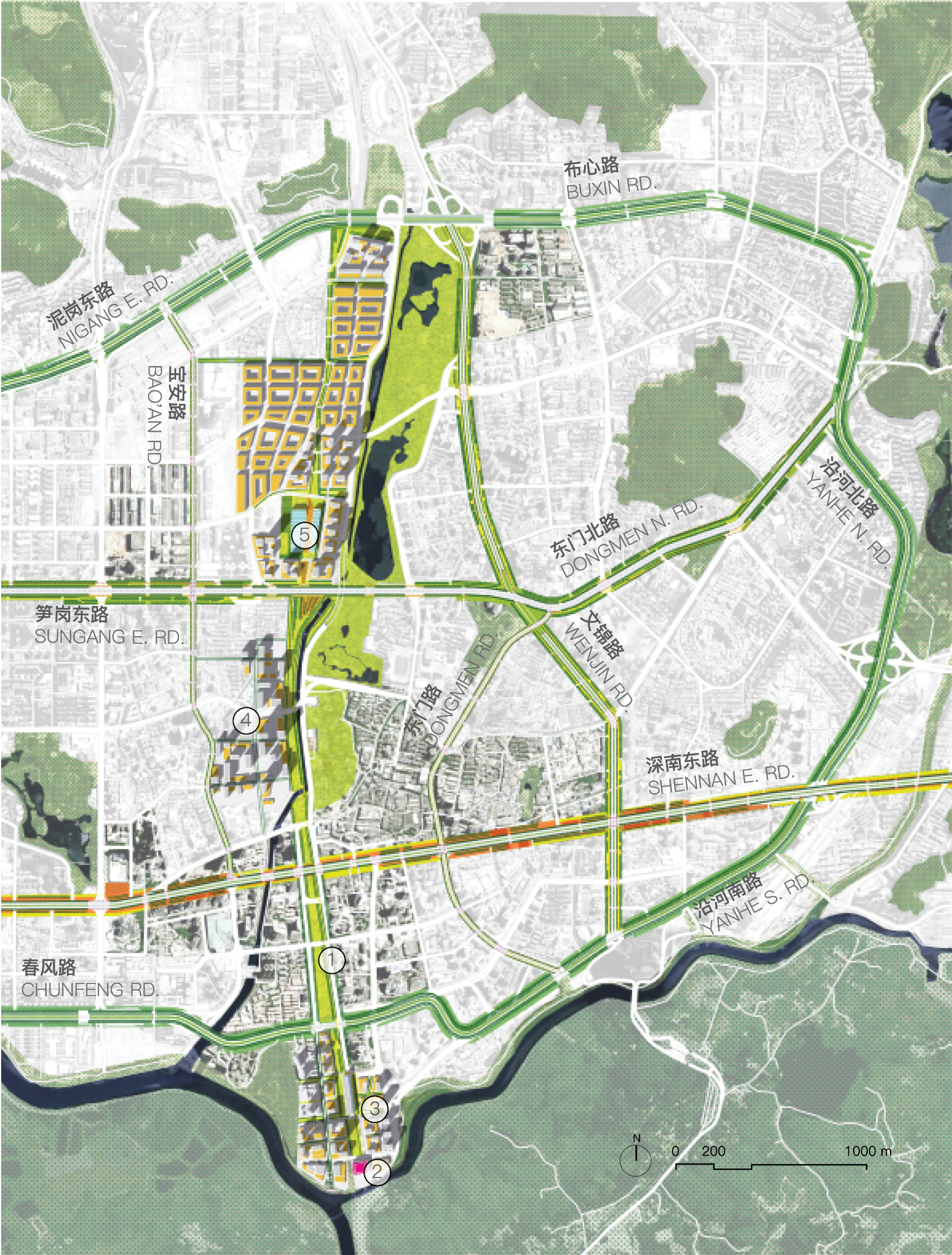
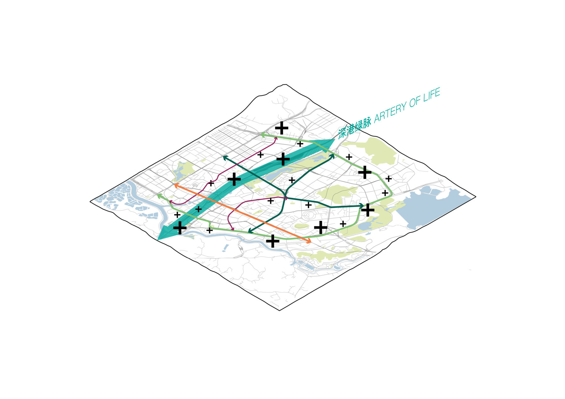
The north-south corridor along the Guang-Shen Railway and Buji River traverses the center of the district, becoming a huge barrier in creating an interconnected urban fabric
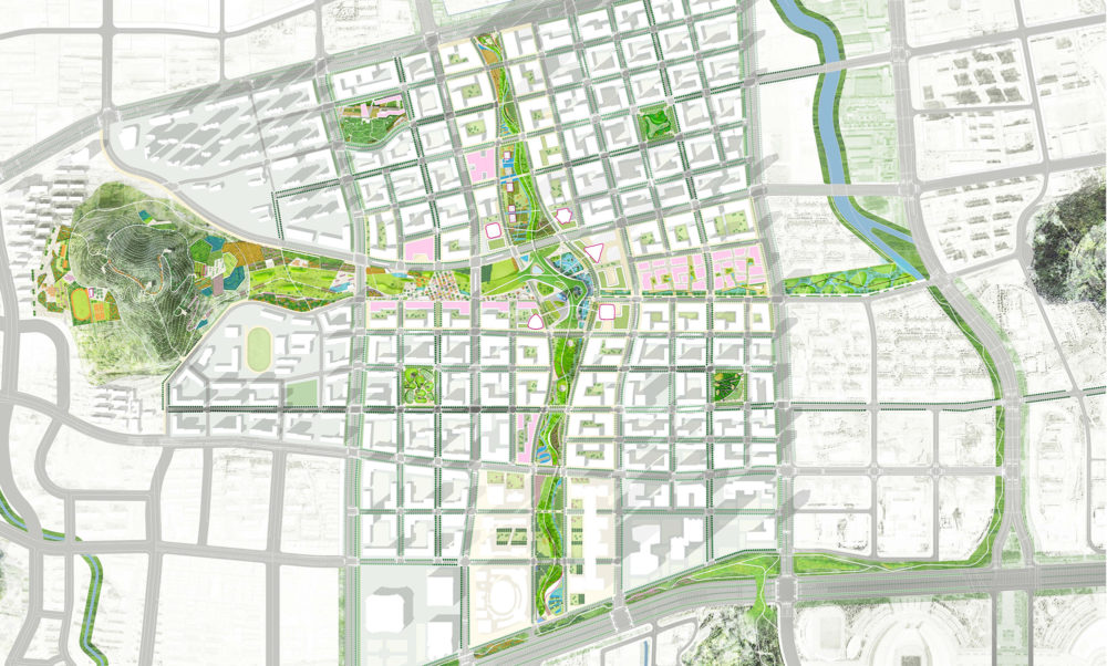
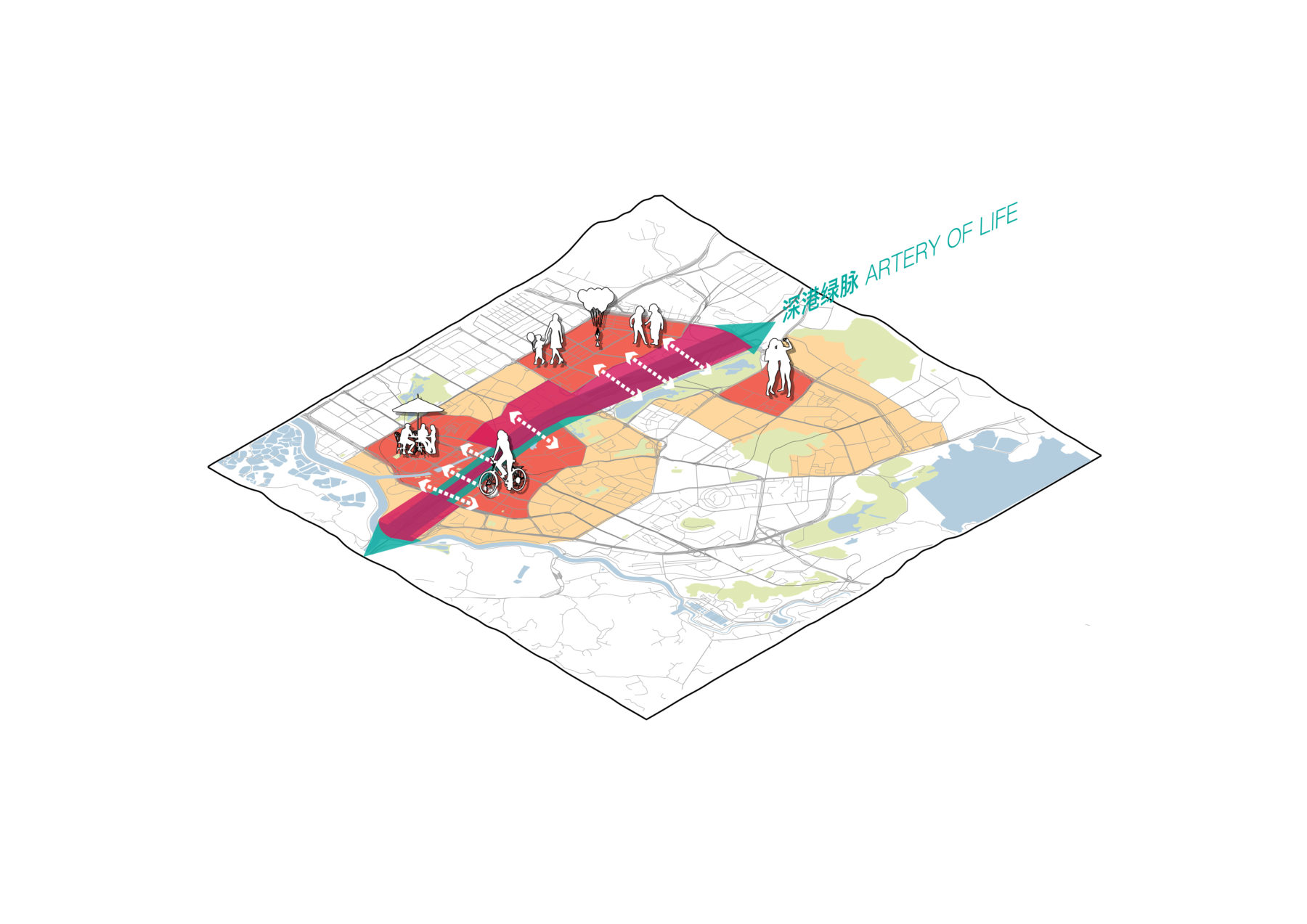
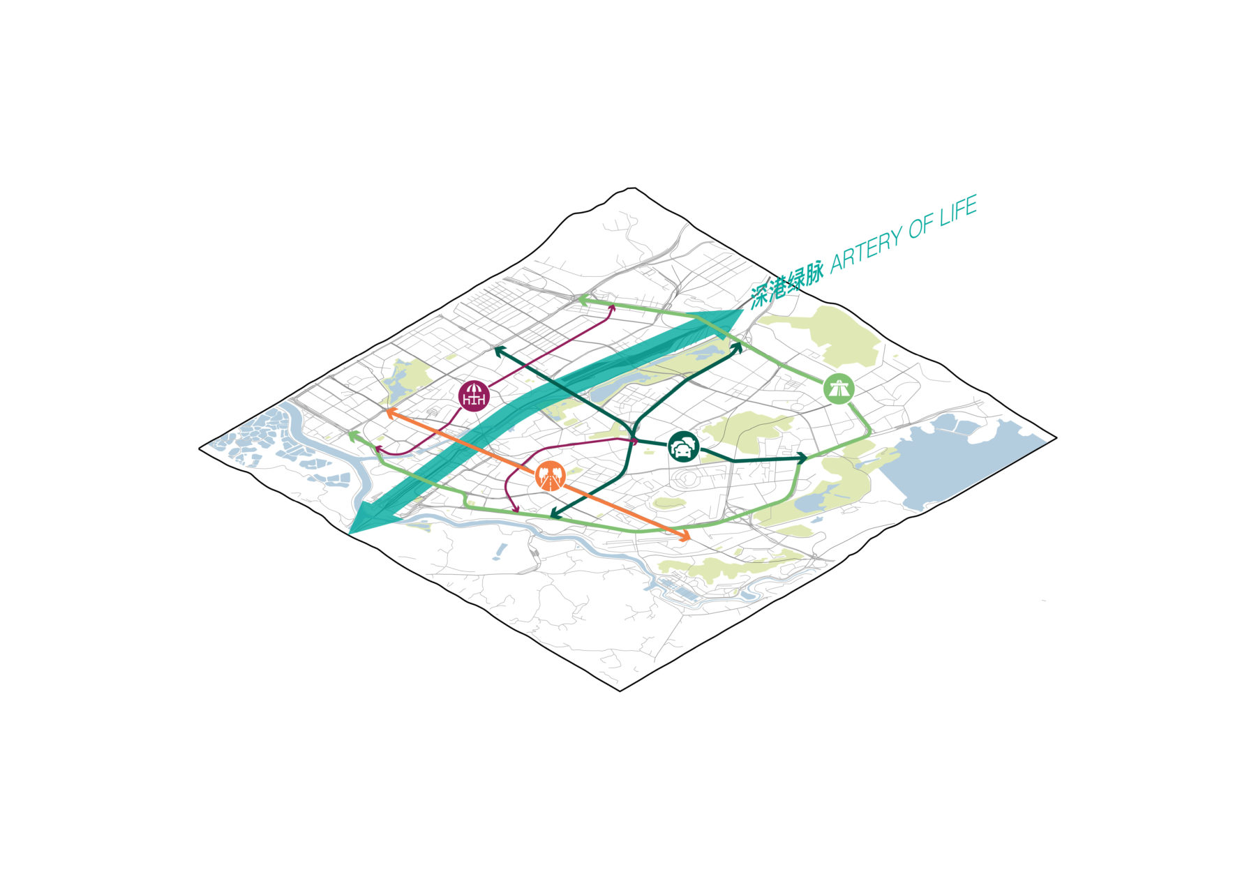
The project’s overall design concept, “From Luohu Bridge to the Artery of Life,” uses public open space corridors and transportation hubs as catalysts to rejuvenate Luohu into a more vibrant urban district. The plan restructures Luohu’s open space system by redeveloping former industrial and transportation land for vital urban uses and creating a public space network along the former railroad, the existing river course, and major public streets. The new design replaces Luohu Bridge, the limited transportation linkage established 40 years ago between Shenzhen and Hong Kong, with the Artery of Life, a continuous public realm system from the Wutong Mountain range north of Luohu all the way to the large ecological reserve in Hong Kong.
Take public open spaces and a transportation hub as catalysts for the holistic transformation of the district
Convert existing industrial parcels into vital uses in urban life and introduce surgical redevelopment at strategic locations to improve the overall urban structure
Promote infill projects to improve the Luohu’s image
Celebrate the unique character of each public street while improving circulation for pedestrians and bike riders
The Artery of Life, which runs through the center of Luohu District, builds upon the north-south corridor along the existing Guang-Shen Railway and Buji River. It will connect Luohu Port and Hong Kong on the south with the proposed Sungang redevelopment zone and Wutong Mountain on the north, through the city center. The Artery of Life will become the spine of the public realm and a new gateway to Hong Kong and the world, catalyzing urban regeneration and industry renewal of adjacent areas.
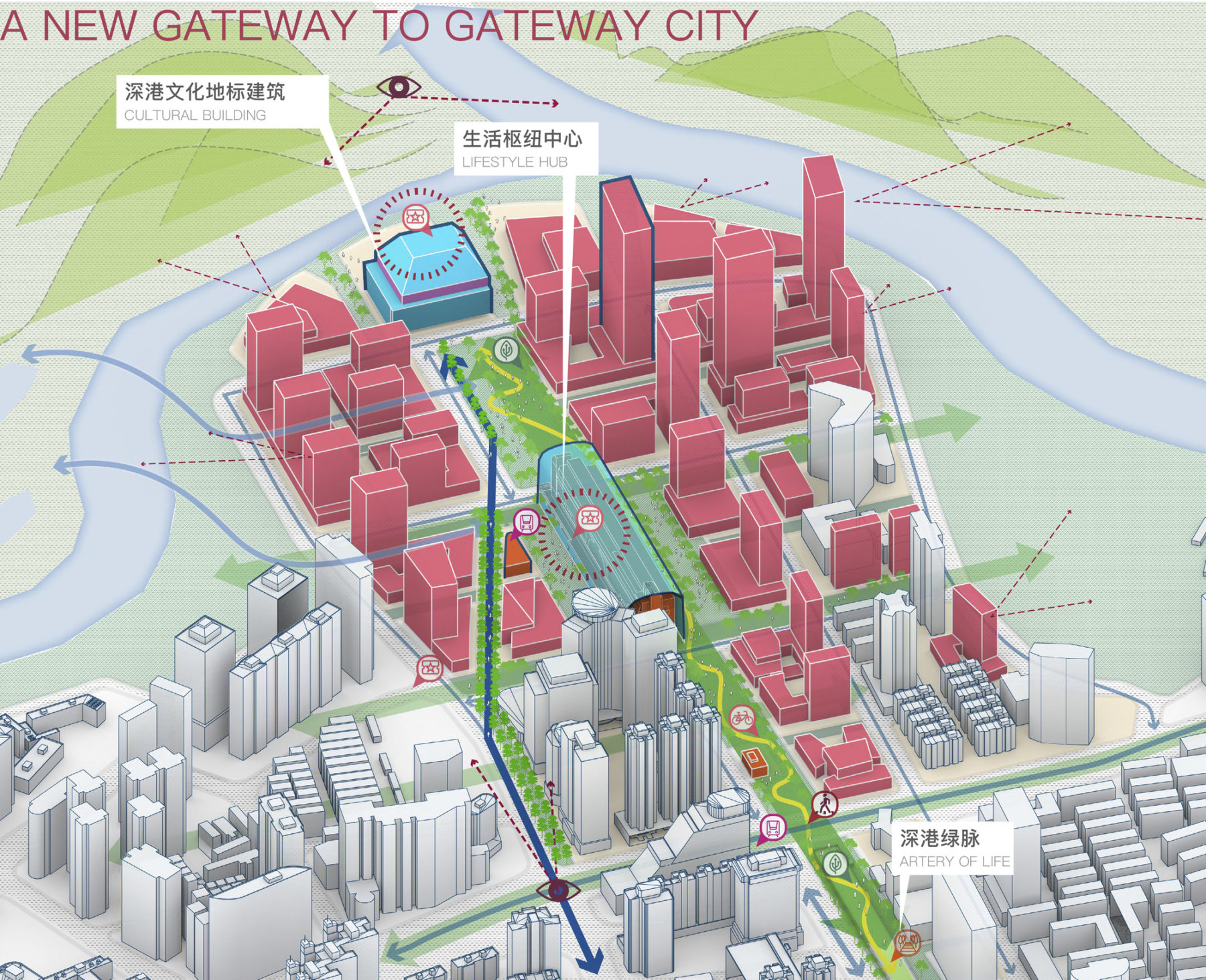
A new gateway to Hong Kong and the world is proposed by transforming the existing Luohu Port and Luohu Railway Station area into an energetic lifestyle zone
With the construction of the new Sungang High-Speed Railway Station and the underground railway system within the urban area of Shenzhen, the existing rail yard and the under-served neighborhood in Sungang Area will be transformed into a contemporary mixed-use district and a new urban magnet, revitalizing the former industrial zone on the north of the district.
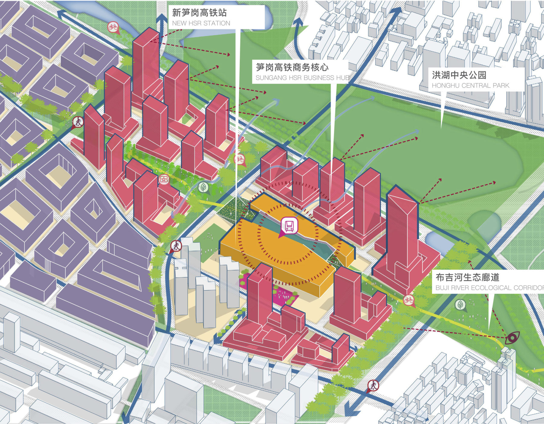
Based on the existing railway warehouse area, a new hub is envisioned to integrate the Sungang high-speed railway station, mixed-use developments, and large green space
Individual characteristics of each street are celebrated based on their existing conditions and positioning for future. Dedicated bike lanes and clear right-of-way for pedestrians are proposed to provide a safe, slow, and engaging experience on the street level. Various programs organized in diverse spatial forms will compliment the uses found within adjacent commercial, office, residential, and civic buildings. With holistic renovation, the streets will serve as major platforms for exciting urban living.
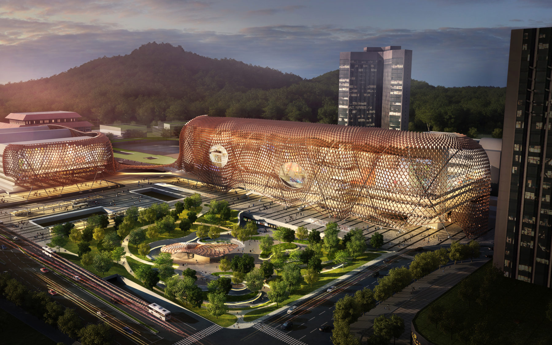
The railway station’s innovative and sustainable façade renovation helps ventilate indoor spaces with a thermo-dynamic design
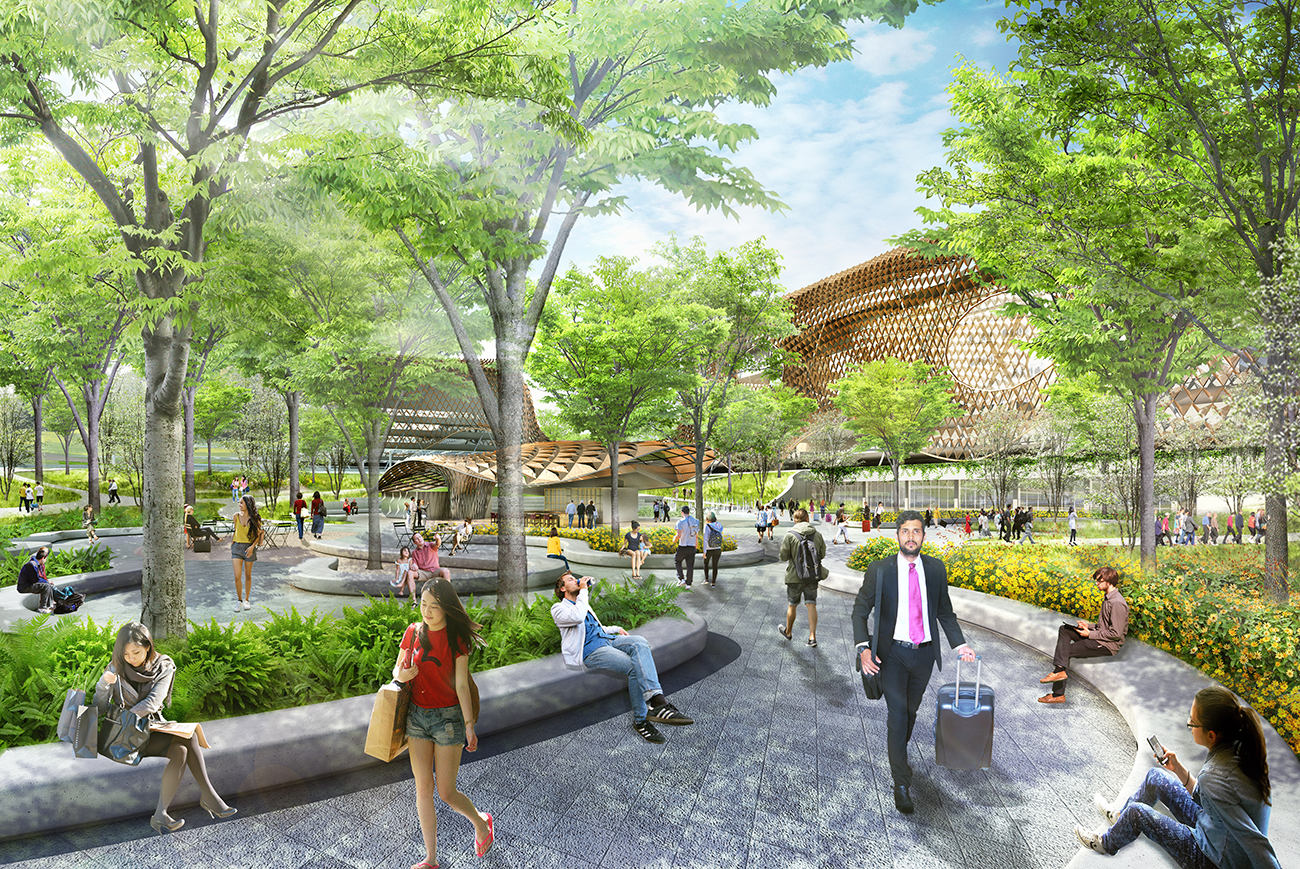
The design enhances the plaza’s function as an extension of the new life center building, creating a sense of “the city’s living room”
The existing railway station near Luohu Port will be decommissioned and converted into an energetic lifestyle hub. Its innovative thermo-dynamic façade helps ventilate indoor spaces to provide a more comfortable experience. The design transforms the building from a monotonous transportation node into a vibrant urban destination.
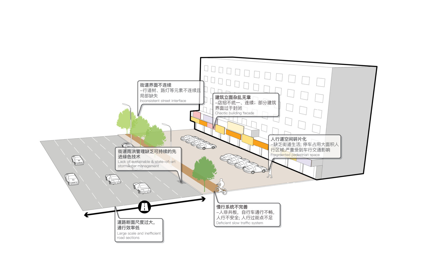
A wide range of problems exist in Luohu’s streets, from road scale to building facades
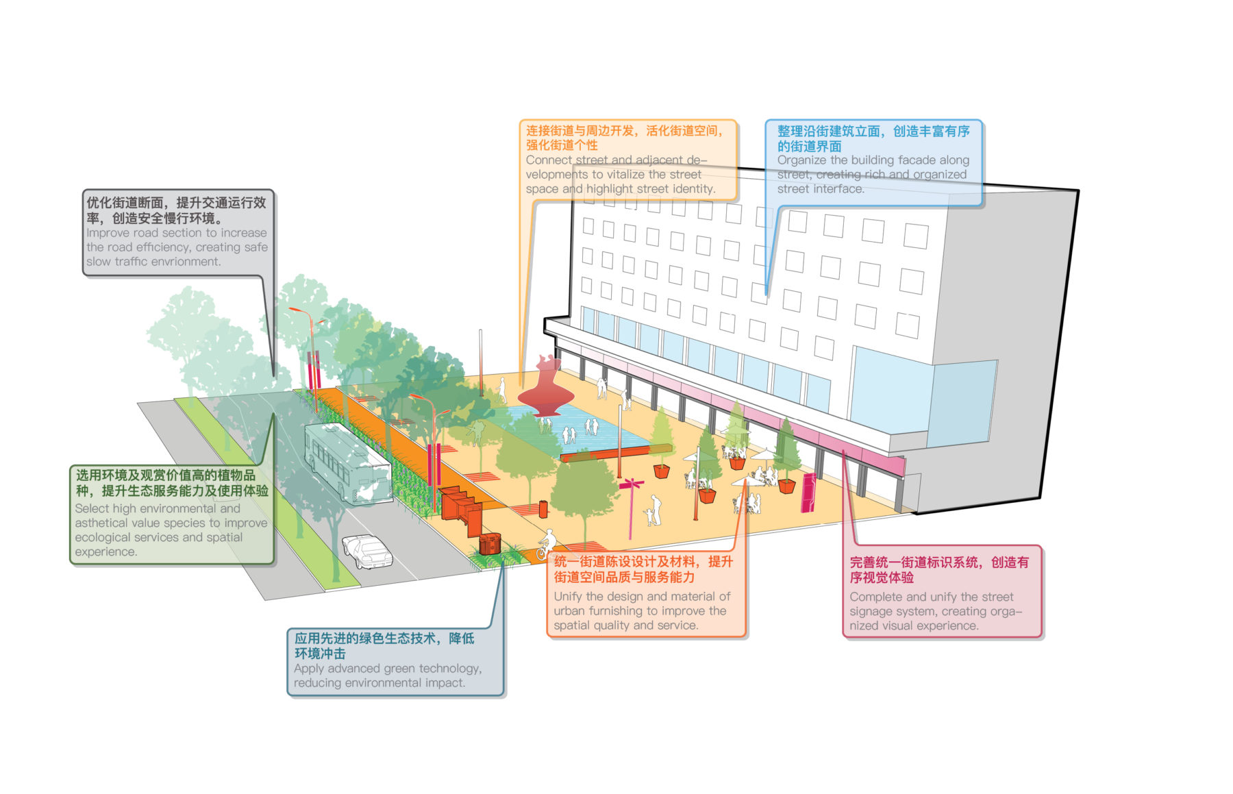
Seven aspects are studied and integrated into the streetscape design. The renovated streets will provide more efficient urban services and higher-quality spaces
The front park of the lifestyle hub integrates with the basement programs through the kiosk and sunken garden, providing a comfortable outdoor space extending activities out from the building. It creates a sense of the “city’s living room,” not only serving the customers of the hub, but also offering a valuable open space for civic use in this dense urban area.
This road is a main transportation corridor, with wide vehicular travel lanes and large setbacks. The pedestrian space is envisioned as various rooms to engage urban life
Multiple strategies are adopted to reduce street scale, activate building frontage, enrich street life, and improve stormwater management
Extending from the Artery of Life, the open space network follows major public streets in the district. By holistically improving existing developments along the urban frontage and placing infill projects at strategic locations, the plan creates complete streets that promote slow traffic and resiliency, integrate with urban life, and celebrate each public street’s unique character.
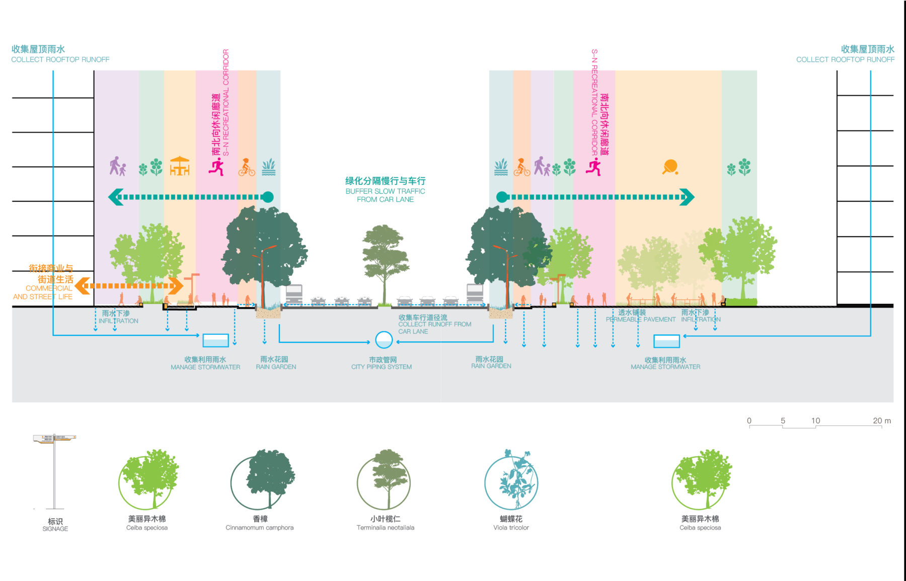
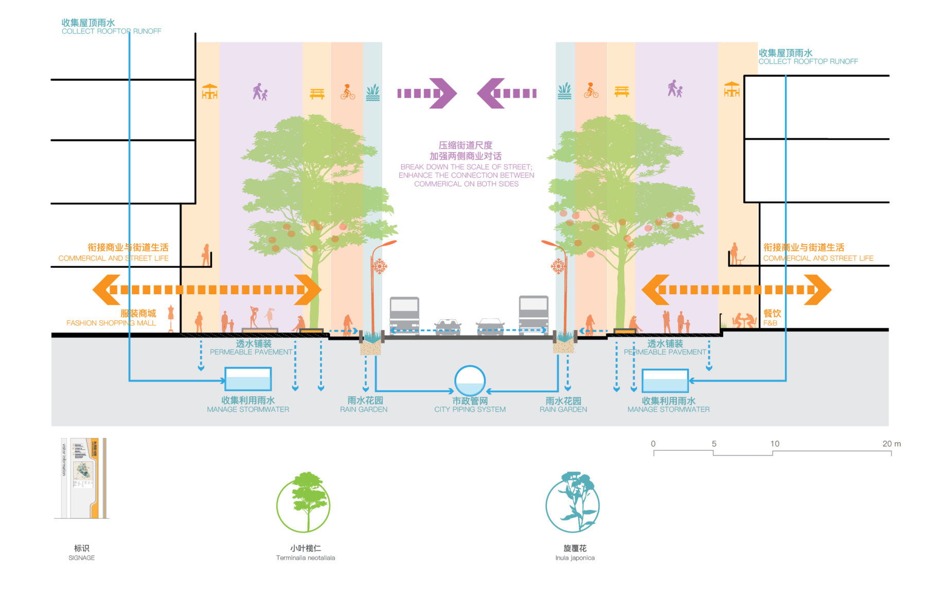
Streetscape improvements are addressed in seven aspects: transportation, program, building façade along the street, stormwater management, planting, site furnishing, and signage systems.
By limiting the number and width of vehicular travel lanes and promoting public transit over the use of personal cars, street spaces become more compact, contributing to the district’s urban scale. Designated bike lanes are integrated into the street section to facilitate the “last one kilometer” commute between transit and various destinations.
The existing plaza is opened up to create better conversation between the street and the building. Taxodium distichum is introduced to bring bright fall colors to the space
The existing pedestrian overpass is renovated with a new accessible path, creating equal crossing opportunities for people at a range of ability levels
Rain gardens along medians as well as permeable paving at pedestrian spaces reduce street runoff, recharge groundwater, and divert filtered stormwater to cisterns for maintenance and operational uses of the public realm. Street-side rain gardens also provide important urban habitats for birds, insects and other invertebrate species, contributing to the ecological value of the urban district.
The plan preserves all existing trees and plants rows of new trees along the sidewalks, bicycle lanes, and road medians to create a comfortable microclimate, seasonal color, urban habitat, and pedestrian-scaled streets.
A continuous green corridor, separated from traffic, is created along the road, improving the spatial quality of the street as well as providing more recreational opportunities for the community
Diverse programs are integrated in the park-like space to serve adjacent residents. Ceiba speciosa is planted to celebrate the energetic atmosphere
The building façades are renovated to promote interaction between the building program and street life by increasing its transparency, adding balconies, and reorganizing retail signage along the podium level.
Diverse programs organized in various spatial forms along each street will complement the uses of adjacent commercial, office, residential, and civic buildings, with an integrated family of site furnishing and wayfinding system designed for the entire Luohu district.
Along retail-fringed streets, such as Bao’An Road, new urban balconies will be introduced at the first and second levels, blending private and public spaces, bringing stores more commercial opportunities while activating the public realm with more street life.
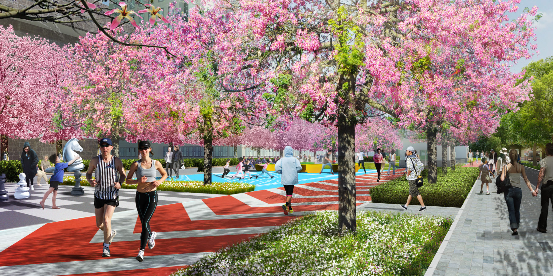
In the vegetation-buffered streets, such as Wenjin Road, which is surrounded by residential communities and schools, a recreational corridor with a series of program spaces will take advantage of the existing green buffer. The corridor will provide precious recreational spaces for the nearby communities in this densely populated area, as well as link the neighborhood with nature.
At Shennan Avenue, the thoroughfare of the city, trees planted in the medians scale down the monumental street, while pedestrian spaces on either side carve out a series of urban living rooms from the large setback, creating spaces for cultural exhibition, outdoor dining, and small gatherings, serving nearby office workers and visitors.
Taking advantage of the wide sidewalk and adjacent retail, the design enhances interaction between the developments and public space
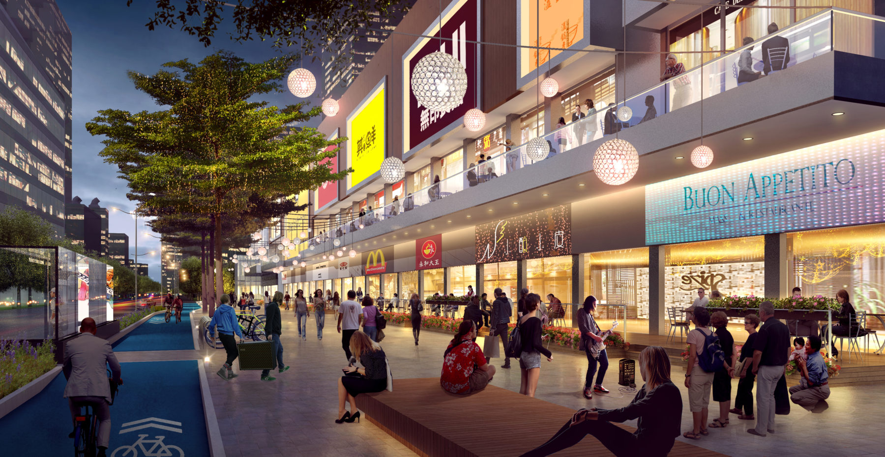
Retail protrudes into the street via urban balconies. Street life is catalyzed between the street and buildings, with diverse interaction at multiple levels
Existing pedestrian overpasses will be renovated to serve people with a range of ability levels. The new pergola structure over the existing overpass, made of bamboo and ETFE membrane, will respond to the local climate and shelter people from heavy rainstorms as well as burning sun.
With a holistic renovation, the streets will provide more efficient urban services, higher-quality open spaces, and serve as major platforms for exciting urban living.
Following the master plan, the design team developed the Streetscape Improvement Design Guidelines, summarizing the design principles and typical design approaches for each major street. The guidelines were adopted during this project’s implementation as well as the renovation of many other streets in Shenzhen.