Urban Resiliency in Metro Manila: Q&A with Mary Anne Ocampo
A Sasaki principal discusses her experience working with MIT in Metro Manila
 Sasaki
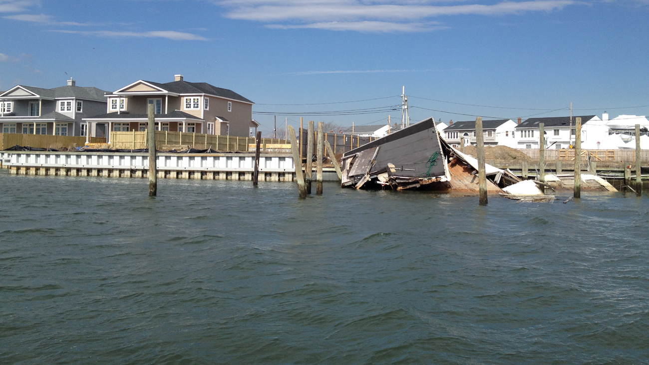
Global climate change is an increasingly local—and regular—reality. Hurricane Irene and Superstorm Sandy left many communities traumatized and exposed much vulnerability in the coastal Northeast.
Thus far, our collective response to natural disasters has focused primarily on recovery and emergency preparedness as an attempt to quickly repair damaged property and restore a sense of normalcy. The efforts of government agencies, community organizations, and the private sector have been largely ineffective at challenging outmoded development patterns, nostalgic lifestyles, and economically, socially and environmentally unsustainable norms. And in the meantime municipalities are expending huge sums of public resources in the name of “resilience”—while many of these solutions remain short term and continue to ignore the larger questions of long-term viability.
Asking these questions is no easy task, and answering them can prove to be even harder. For this reason we have chosen to balance our professional practice with institutional inquiry and to take advantage of the unrestrained thinking and exploration that an academic environment can afford. In the classroom, we can challenge the boundaries of planning and urban design—and then fold innovations advanced through academic inquiry back into practice.
In parallel to Sasaki’s work with the NY State’s New York Rising Community Reconstruction Program, we asked graduate planning students in the Department of Urban Studies and Planning at MIT to imagine alternative futures for south shore Long Island. Students focused on the Massapequas, a community southeast of Levittown, New York, that is characterized by dense single-family suburban development. We challenged the students to consider the site not only as a physical location, but also as a dynamic construct influenced by natural, cultural, economic, political, and morphological forces. Through an intensive semester, students balanced their responses to environmental forces, economic realities, and the community feedback accumulated during the parallel NY Rising engagement process. We asked them to consider these questions:
What does an ecologically sustainable, economically robust, and socially diverse Long Island community look like in the future? In the event of future disasters, where should rebuilding occur and where should it not? In the context of widespread shoreline privatization, what does it mean to be a “waterfront community”? How can productive landscapes be drivers for development and serve as meaningful community green spaces?
What is the long-term viability of homogenous, single-family dwellings in the context of changing demographics? What are the options for an aging community to remain and age in place? Who will bear the future tax burden? Are there opportunities for young professionals to live within their means? Can local workers afford to live in the communities in which they work? Is there untapped capacity for transit-oriented development near LIRR stations?
By the end of the semester, students developed adaptive urban design scenarios and imagined new futures that balanced the need for tactical responses to storm impacts with long-term visions for a more resilient region. Strategies included:
Read more details on the students’ work below, and click on the thumbnails to view images.
Kara Elliott-Ortega, MCP 2015
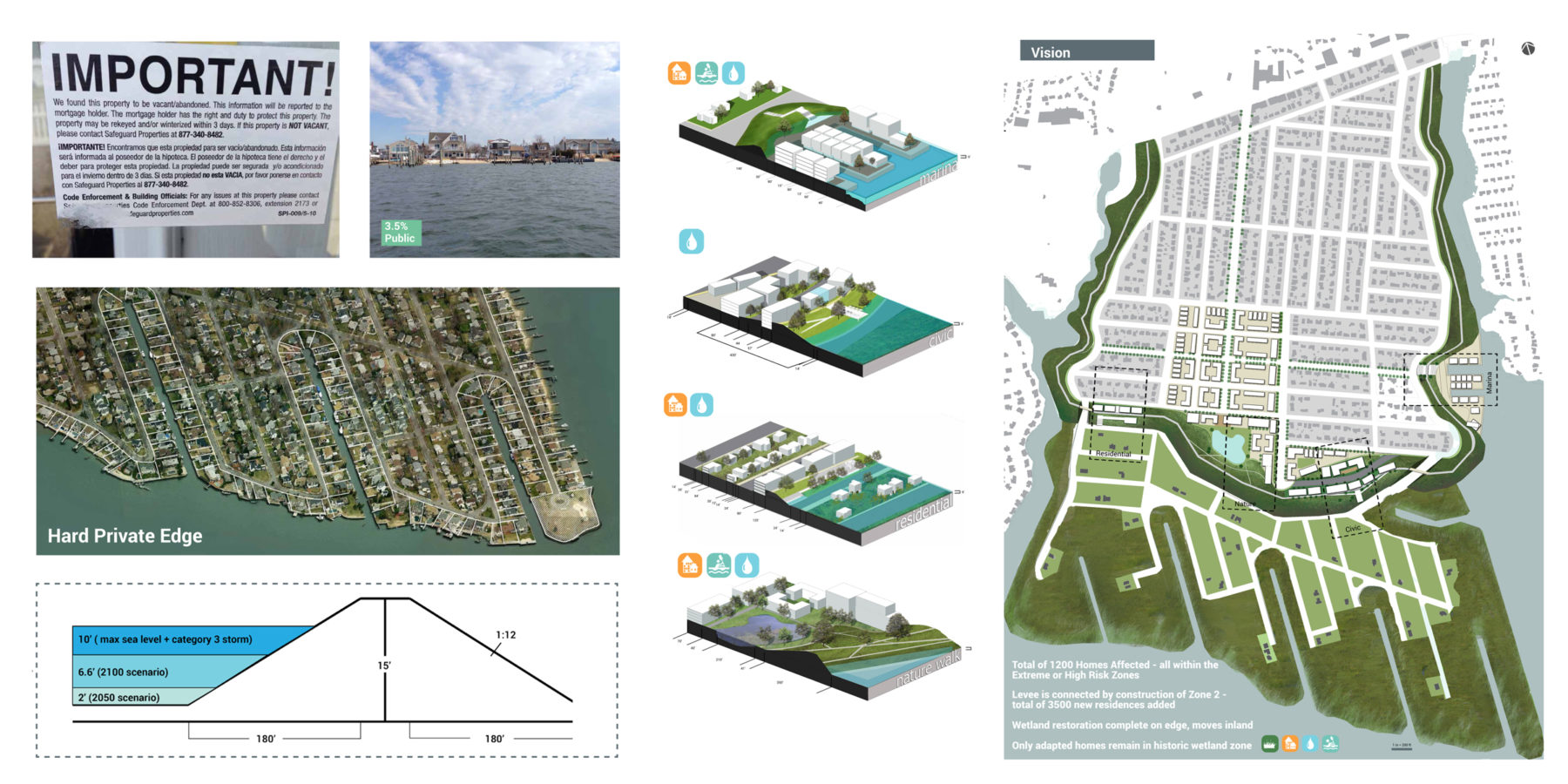
Homes located in “Extreme” or “High” risk zones and in areas historically characterized by wetlands will more than likely continue to experience the destructive effects of climate change. This project takes a strong position against reactive rebuilding by proposing strategies for phased retreat and exploring prototypes for a new suburban-urban and ecologically-derived model. This model positions infrastructure as open space, a community resource, and protection for new and dense inland residential developments.
Adriana Akers, MCP 2015
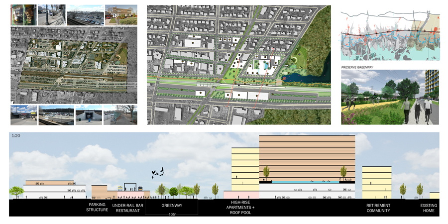
This project proposes focused transit-oriented development at Long Island Rail Road (LIRR) stations. On a site currently characterized by widespread surface parking and low density commercial uses, the development would provide alternative housing options for storm-damaged families, a rapidly aging population, and the local workforce—as well as options to attract young professionals. An elevated LIRR berm provides additional layer of storm protection, as does an active east-west recreational corridor that links natural preserves and mitigates stormwater runoff.
Sunny Menozzi, MCP 2015
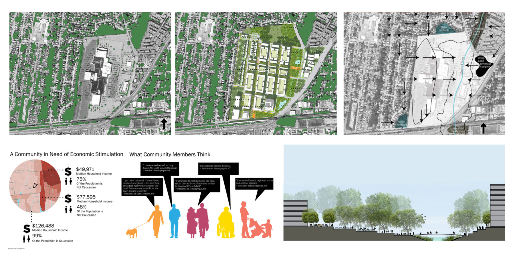
This proposal seeks to balance the social, economic, and ecological challenges by rethinking a 90-acre outdated mall site adjacent to the Long Island Rail Road (LIRR). A new LIRR station will fill a service gap for an area of relatively diverse, densely-packed, and lower-income residents. A regional medical facility will stimulate the local economy by introducing vital health services for a rapidly aging population. Additional housing will provide rental and home ownership options for storm-torn families, empty nesters, local workers, and future young professionals. Finally, a large green infrastructure intervention will reconnect existing lowland drainage areas, creating natural redundancy to an overburdened storm water drainage system by replacing asphalt with a regional urban wild.
Chloe Schaefer, MCP 2015
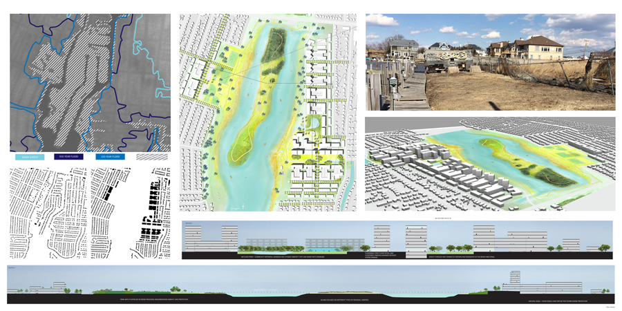
Living on the water presents both risks and rewards. This project reimagines a mostly privatized waterfront as a new and publicly accessible community resource. Taking a strong stance against developing in “High” and “Extreme” risk areas, including areas within the 500– and 100-year flood plains, this project repositions storm-damaged housing on higher ground and creates a dense, amenity-rich, mixed-use development behind a landscape edge, which functions as both a protective barrier from future water hazards as well as an active recreational corridor.
Lilly Jacobson, MCP 2015
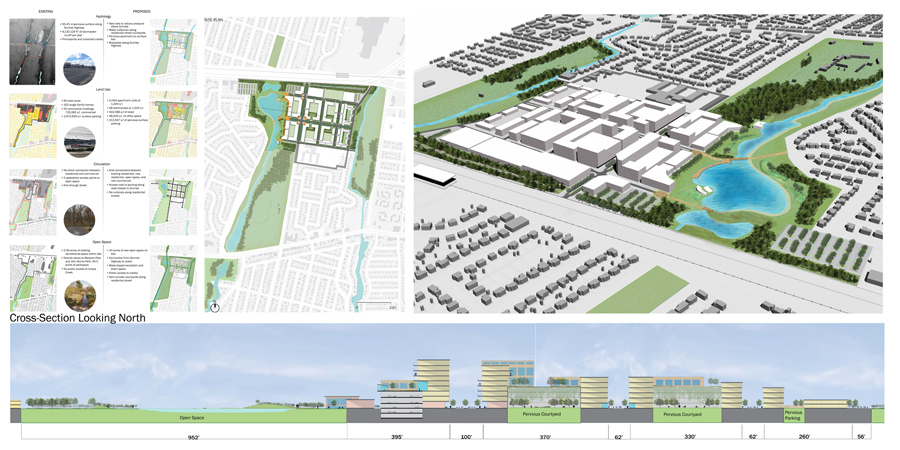
Building on an extensive network of wetland corridors, this project joins a fragmented system of wetland preserves and public parks to create a more connective open space network. Compact mixed-use housing clusters are sited between the corridors to provide affordable housing options, and open spaces are embedded within the block structure to address on-site storm water runoff. A strategy to de-pave lengthy stretches of surface parking along the highway results in linear parking gardens that both increases upland storm water infiltration and improves the visual experience from the automobile.
Alex Brady, MCP 2015
During post-war suburban sprawl, essential civic resources such as schools and parks were largely overlooked and therefore relegated to leftover sites such as wetlands and other low-lying and vulnerable locations. Higher land was devoted to auto-oriented strip commercial developments and dominated by surface parking. This project challenges the preconceived notion of a strict separation of uses and highlights the importance of ecology in public education. Through a strategic partnership among primary, secondary, and higher education institutions and shifting a vulnerable middle school from the flood plain to higher ground, this project seeks to promote environmental stewardship through civic engagement. It blurs the artificial lines between an urban commercial street, a multi-tiered campus, and a dynamic open space amenity.